


Kennamer Cove Cir, Marshall County, Alabama
About
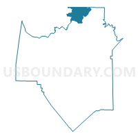
Outline

Summary
| Unique Area Identifier | 522489 |
| Name | Kennamer Cove Cir |
| County | Marshall County |
| State | Alabama |
| Area (square miles) | 17.29 |
| Land Area (square miles) | 17.11 |
| Water Area (square miles) | 0.18 |
| % of Land Area | 98.94 |
| % of Water Area | 1.06 |
| Latitude of the Internal Point | 34.56738790 |
| Longtitude of the Internal Point | -86.28062820 |
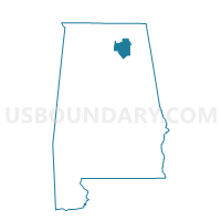
Maps

Graphs
Select a template below for downloading or customizing gragh for Kennamer Cove Cir, Marshall County, Alabama


Neighbors
Neighoring Voting District (by Name) Neighboring Voting District on the Map
- Aspel Water Board Bldg., Jackson County, AL
- Bethel Primitive Bapt Church, Madison County, AL
- Bucksnort Comm Ctr, Marshall County, AL
- Mt Shade Church, Marshall County, AL
- Swearengin Comm Center, Marshall County, AL
- Woodville City Hall, Jackson County, AL
Top 10 Neighboring County Subdivision (by Population) Neighboring County Subdivision on the Map
- Scottsboro CCD, Jackson County, AL (19,895)
- New Hope CCD, Madison County, AL (13,968)
- Grant CCD, Marshall County, AL (10,201)
- Paint Rock CCD, Jackson County, AL (3,518)
Top 10 Neighboring Unified School District (by Population) Neighboring Unified School District on the Map
- Madison County School District, AL (123,029)
- Marshall County School District, AL (47,197)
- Jackson County School District, AL (38,458)
Top 10 Neighboring State Legislative District Lower Chamber (by Population) Neighboring State Legislative District Lower Chamber on the Map
Top 10 Neighboring State Legislative District Upper Chamber (by Population) Neighboring State Legislative District Upper Chamber on the Map
Top 10 Neighboring 111th Congressional District (by Population) Neighboring 111th Congressional District on the Map
Top 10 Neighboring Census Tract (by Population) Neighboring Census Tract on the Map
- Census Tract 302.01, Marshall County, AL (5,381)
- Census Tract 302.02, Marshall County, AL (4,820)
- Census Tract 114, Madison County, AL (4,339)
- Census Tract 9507, Jackson County, AL (4,272)
- Census Tract 9505, Jackson County, AL (3,518)